I mean geology that makes your heart race, your pupils dilate. Rocks and exposures that make you feel woozy and warm. Structures and concepts that make your skin alternately sweaty and covered with goosebumps. Places you’ve visited, read about, or seen photos of that make you feel weak-kneed, and induce a pit in your stomach.
Click over to read the full description of what this month’s topic is (and is not) meant to entail. If you have a post to submit, please leave a comment and link either here or at the original call for submissions, so I can find it when I go to assemble this edition.
What have you left behind in the field? What have you lost or what do you regret not having collected, including photographs? [Before going further, I would like to thank all of the participants.]
The first contributor, Evelyn Mervine recounts some fascinating field work in the Indian Ocean, then she goes on to relate what she regrets not bringing home – a baby goat or a baby camel from Oman. I wonder what U.S. Customs would have had to say about that? [I once used a large paper cup to catch a kangaroo rat (for a few minutes) in the Eagle Mts. of West Texas, but it wouldn’t have acclimated to a caged existence.] If one lived on a farm, bringing home such “souvenirs” from the field might work, but not so sure in a two-bedroom apartment. I don’t know whether goats and camels can be housebroken. Here is her post in its entirety.
From Ann’s Musings on Geology, Ann muses on her extensive 35-mm photographic past and photos she didn’t get. She recounts such issues as not wanting to expose her camera to adverse conditions, e.g., dust or rain or not wanting to carry the extra weight. [Been there, done that on both counts.] She also described the familiar college-student issues, such as the expense of film purchases and development costs. As I did, she chose slides as they were cheaper. Another constant issue with 35-mm film photography, you had to wait to know if you got one or more decent shots. Many times, once she found out that she didn’t get a good photo, it was in a situation where there were no do-overs, no chance to revisit the site. [Another 35-mm hazard – forgetting to reel the film back into the cartridge before you open the back of the camera. In 1982, I lost all of my Wisconsin glacial features slides when I did this.] As I do, she now faces the dilemma over what to do about all of those slides and how to convert them. Hopefully this can be resolved in a satisfactory way, with a scanner of some type. [I have a scanner, but not the time.]
Dana Hunter also reminisces about the Photo Not Taken. Actually of the photos not taken when she lived in Arizona. The empty photo-box syndrome. I can attest that there is plenty of good geology to be photographed in all of Arizona, especially the northern half of the state…San Francisco Peaks, Page, Sunset Crater, Grand Canyon, Sedona, Jerome, Barringer Crater, Canyon de Chelly, Shiprock,…
Silver Fox at Looking for Detachment is the first to report on regretting leaving a geological/archeological item in the field. From her account, after being literally dropped-off by helicopter at a field site: …”I found a large pink projectile point in the middle of the drainage I was walking down, a drainage that had obviously seen some flooding in the last 1 to 5 years. The point was possibly made of Ivanhoe “chert” (more precisely opalite or silicified tuff) from the Tosawihi Quarries of northern Nevada, a large series of rock quarries made by ancient to nearly present-day native Americans…” In following accepted archeological protocols, she left the point, intending to mark the locality on a map for later collecting by a “trained professional”. For whatever reason, the info didn’t get passed along and the point was probably washed further downslope with later weather events. [I once got a polite lecture from a friend about collecting a silicified limestone “hand tool” from a roadside site, but I was able to drive him to the site and point to the exact location, so he could relate it to his archeologist girlfriend, so no damage done.]
The next contribution comes from Egypt! Way cool. Selim Abdelrhman reports on the strange rocks of Wadi Elbattekh in Egypt. From his words: “OK, Wadi Elbattekh or وادي البطيخ my translation is “Watermelon Valley” it’s aWadi filled with strange rock shape and very soft in touch. i think the origin of this rocks is still a mystery.”…
From Casey at Giosciencecomes regrets of not having collected more samples (and taken more photos) of ripple-marked sandstones during at 1998 GSA Southeastern Section fieldtrip in WV, a fieldtrip that included the legendary sedimentary petrologist Bob Folk. The ripple marks were in the Devonian Foreknobs Formation, part of the Catskill Delta.
The proprietor ofGeologyMelange brings us his first geoblog post. The subject of regret was a past visit to part of Marble Canyon in Death Valley. Of most interest was an apparently un-mapped outcrop of deformed crinoid “hash”. There were a sufficient number of photos taken, but no measurements were taken of the size or orientation of the outcrop and not enough samples were collected. But of even more interest were the cobbles of white marble, the origins of which were not discovered.
A photo of Christopher with a fault-breccia in Marble Canyon, just above the canyon sediments.
Ron Schott admitted not collecting enough samples from certain sites, taking enough notes, or taking enough photos. But his greatest regret was losing his first Estwing Rock Hammer, which he was given as part of his Colgate Univ. Field camp gear. It served him well in field camp, but when he visited Giant Mountain in the Adirondacks, the spirits of the mountain became incensed at his collection of samples of the Roaring Brook intrusion breccia. The spirits extracted their revenge by relieving him of his beloved hammer from its improvised rope belt. [I know the feeling. My Dad gave me a brand new Estwing Rock Hammer when I left home to go to UTEP for grad school. Despite having the handle wrapped with day-glow orange tape, I managed to lose it in the Eagle Mts., about a year and a half later.]
Jessica Ball (aka Tuff Cookie) has a similar story of losing a “first piece of field equipment”, a little smaller, but still important. Somewhere in the area of Sugar Hollow in the Virginia Blue Ridge Mountains, her first hand lens slipped off its lanyard. From a separate adventure, she regrets not having kept her first pair of hiking boots, with partially-melted soles from an encounter with some of Kilauea’s fresh lava flows. I am sure that those boots would have been good for some stories.
For my contributions, there are actually two different ones. In 1979, I had a summer job in the San Juan Basin of NW New Mexico, as part of a fossil recovery project, prior to the opening of an open-pit coal mine. Outside of our project area – on the road back to the dirt “highway”, there was a reddish-colored outcrop of “clinker” material, i.e., baked Cretaceous shale with plant fossils. The baking was probably courtesy of an ancient, underground coal-seam fire. After driving by this site to – and from – my “days off”, I decided to stop and have a look. I regret only picking up two specimens from this site, one (pictured) with an angiosperm leaf and a stem fragment and another with a piece of a stem. WHY DIDN’T I AT LEAST FILL A BUCKET FROM THIS SITE? I will never know.
The image is labeled for use in my classes.
The other under-collected site was the previous summer, when I was in the Eagle Mountains in West Texas. While surveying the area – as part of a planned thesis project, which was never finished, in favor of another a few years, later – amid the caldera breccias and ash flow tuffs, I found a chunk of siltstone, with some tiny impact craters. I regret not even doing a rough draft of the extent of this intra-caldera siltstone. It most likely was reworked, water-deposited ash, with roughly-defined bedding planes. The surface was marked by a few tiny impact craters, suggesting bombardment by explosion debris, while the upper surface was exposed, but soft and “plastic”. Looking at cross-sectional view, there was evidence of other small impacts by broken crystals/rock fragments. I often include this in lab instructions to remind students that it is possible to find sedimentary rocks inside of volcanoes. SO WHY DIDN’T I PICK UP MORE CHUNKS OF SILTSTONE? [BTW, the place where I lost my Estwing rock hammer was a stop or two past the siltstone locality. Hmm, is there a connection?]
[Update: A couple more attendees to the party!]
Water and Rocks…At The Same Time reports on the discovery of a chevron fold in an outcrop of the Dolgeville Fault on a tributary of the Mohawk River, near Dolgeville, NY. The photo at left shows a portion of the fold. Several members of the field trip party picked up folded portions of (presumed siltstone), but Roy didn’t want to add anymore clutter to the crowded van (be there, done that on a crowded field trip bus, it is hard to keep samples organized and under control). This was his 2nd chevron fold, the first he donated to his alma mater, SUNY Oneonta. Roy, you have my permission to collect the next chevron fold for yourself.
Dr. Ian at Hypo-center reports on some important items ALMOST LOST during field work in Lukmanier Pass region of Ticino, Switzerland years ago. After picking up a fair-sized sample of gneiss: …”I was crossing a boulder field and noticed an interesting looking exposure up a steep face to my right. I put my notebook down on a rock, placed my map case on top of it, and my gneiss sample on that to stop it blowing away. I then headed up to the steep outcrop with my compass-clinometer thinking I could easily remember a couple of readings and rock details and return to record the information in my notebook.”… After climbing upwards to check out more interesting metamorphics and record several more structural readings, he turned around to re-orient himself and return to collect his sample, notebook, and map case, when he realized – “Just damn! – all them boulders look the same!” (or something like that). More from Ian: …”After an hour a mild panic started to set in. Had I just lost three weeks work down to my own stupidity? Since I knew that they had to be in the boulder field somewhere,…” He searched for two more hours. At the point of almost giving up hope, he decided to do two more passes through the boulder field, then he realized that the items of interest were a mere 10 meters away from him. But a sad postcript follows this reunification of geologist and field equipment… …”After my degree, I went to Cardiff to do a Ph.D. and I told the metamorphic petrology lecturer about the wonderful metamorphic rocks at Lukmanierpass, including hornblende garbenschiefer and kyanite schists…I showed him the box of my rock samples that I had collected there. He asked if he could hang on to them for a while and I agreed. With the passing of my Ph.D. I completely forgot that I had lent him the rock samples. I moved on to Keele, and he moved on from Cardiff.” So the location of the box of rocks is a mystery.
Well, us Geologists and our stories of “the ones that got away”. Maybe some younger folks will learn something from our travails, lost samples, unphotographed localities, lost equipment, and regrets.
“What do you regret leaving behind at a geological locality?” In other words, what samples, specimens, or even photographs do you regret “not getting enough of”?
So I post the Accretionary Wedge #34, pack up the tents and roll the carnival out of town, and what happens? People who should’ve been part of the show turn up. Seems we’ll have to roll back in, then, because these acts shouldn’t be missed!
Due to Twitter not notifying me of a critical message, Anne Jefferson’s brilliant “Bacteria in the sky, making it rain, snow, and hail” got left at the side of the road. And that’s bad, because it’s headspinningly weird! Biology contributes to hydrology which is part of geology contributes to biology and around and around we go! The remarkable interconnectedness of all these things – life, water and rocks – can make dizzy. Kinda feeling like I’ve been standing in the center of a really fast merry-go-round now…
Speaking of standing in the center of things that make you feel funny, Helena’s Weird AND Scenic scenery at Craters of the Moon will leave your head spinning happily. What’s weirder than a landscape that looks like “black vomit” and is so heavy that it’s sunk a 100km region right down? Rafting volcanoes, dragon skin, a maclargehuge rift – that’s weird and no mistake!
While we’re on the subject of craters…. My Intrepid Companion likes to pretend he’s got nothing to say about geology, but he does. And he seems to think a maclargehuge hole in the ground caused by a meteor isn’t weird, but when you think about how rare it is to find one this perfectly preserved on Earth, what with all our various agents of erosion, it totally is. So, go feast your eyes on what happens when outer space geology smacks in to Earth geology.
Garry Hayes at Geotripper rather made my jaw drop with this one: Weird Geology: Accretionary Wedge #34…Our Human Nightmares. Because I hadn’t put geology and pareidolia together before, but he did, and it’s fascinating. Beautiful. And just a little deliciously scary.
So you see, my darlings, why this carnival had to roll back in to town. The world is far more weird (and wonderful) than we’d revealed in our original installment. And over this next year, keep your eyes open for odd, outrageous, and ooo-inducing geology, because we’ve not yet exhausted this topic, and you could run away and join the weird geology carnival next summer.
People had been running into seashells on mountaintops for years. Seashells. On mountaintops. “That’s weird,” they said, and eventually, some clever types not content with “Funny old world, innit?” and “God must’ve done it” arguments said, “That’s really weird. How’d they get up there? How, in fact, did mountains get there?” And then you had Hutton sailing people around to Siccar Point and pointing out the rather dramatic angular unconformity there. Now, that was weird. So weird he took twenty-five years and a very verbose book to explain it.
Now, of course, we don’t think it’s all that weird. But that’s only because it’s familiar. It’s like your Great Aunt Vanessa, whose personal quirks like dressing every square inch of exposed furniture surface in doilies and pontificating on the personalities of her plants strikes first-time visitors as mightily strange, but after you’ve got used to her and had the origins of those oddities explained away, just seems charmingly eccentric.
I mean, the very idea that these big ol’ solid continents go rafting round the world was so laughably ridiculous on its face that nearly everybody laughed at poor old Alfie Wegener when he floated the idea. Sure, everybody’d looked at a map of the world at some point and went, “Hmm, Africa and South America are a perfect fit. Well, that’s weird,” but not as weird as Wegener’s idea – until the evidence piled up, and everything fell into place, and the mountains made sense, and now everybody who knows anything about geology doesn’t think plate tectonics is all that weird at all. But it is. Really, really weird. Just because something makes perfect sense and can be proven scientifically doesn’t mean it’s not strange.
It’s hard to remember how weird all this stuff really is. Which is why I invited all you all to hop in the wayback machine or scurry out to the field in search of bizarre, befuddling, or simply baffling bits of geology. What follows is a carnival sideshow of Weird Geology. Step right this way, ladies and gentlemen, and feast your eyes on mind-boggling minerals, eccentric erratics, and a veritable smorgasbord of delightfully strange stones!
Step right this way, ladies and gentlemen! Hear Metageologist at Earth Science Erratics announce, “Chalk is weird.” Surely not chalk, you say! But surely yes! This dull, dry, bland-tasting (admit it, you had a nibble, perfectly normal for a geologist even though you weren’t technically a geologist at that age) and indeed chalky rock is indubitably weird, and, dare we say, even strange. See chalk as you’ve never seen it before!
And speaking of seeing, don’t believe your eyes! Geology is a master of illusion. Venture into Magma Cum Laude’s tempting tent, and Jessica shall show you illusions that will leave your brain befuddled and your senses insensible! It’s all here in Weird Geology: Accretionary Wedge #34, wherein it is proved that seeing should not always be believing.
Weird Geology? Holy Haleakala, what’s weirder than molten rock? Let Matt at Research at a Snail’s Pace show you there’s nothing ordinary about rocks melting deep in the earth!
And then, ladies and gentlemen, come this way and walk on land – moving land, that is! That’s right, Rachael at 4.5 Billion Years of Wonder has a Slow Motion Landslide that must be trod upon to be believed! It will give a whole new meaning to “the earth moved.” Guaranteed!
Watch your step, folks, watch your step! That may be Quicksand you’re headed for! At Ron Schott’s Geology Home Companion Blog, it is proved “that not all terra is firma,” a lesson you won’t soon forget!
Hoodoo? Voodoo? Erosiondoo! Phillip at Geology Blues knows that Goblin Valley is Weird! Take an eerie journey through the hoodoos, at night, on Halloween – the only way to see your truly weird geology!
Oh, but ladies and gentlemen, Malcom at Pawn of the Pumice Castle has landforms that are not only weird, but unsolved! Accretionary Wedge #34: That is Weird will introduce you to the great and terrible mystery of Mima Mounds. Prepare to be amazed!
And, speaking of mounds, go Geocaching and discover Quellschwemmkegel – mounds created by springs. No mystery how these formed, but plenty weird, as Ole well knows!
Ladies and gentlemen, you’ve seen breccia, but never like this! You will marvel, you will ponder, Silver Fox of Looking for Detachment will prompt Some Thoughts on Weirdness, and A Picture (or Two) (or Three) – and what magnificent pictures they are! How big can breccia be? Come this way and find out!
Rocks can be magical, and what could be more magical than a crystal-filled rock appearing where no rock has ever been before? Special to AW-34 Weird Geology, a blast from the past, Ann at Ann’s Musing on Geology and Other Things has the story of a stone rafted on ice, buried, and brought to the surface by frost. Marvelous!
Continue your tour of Accretionary Wedge 34: Weird geology at Hypo-theses, where Doctor Ian will show you rocks that will make you gasp, yes, gasp in shock and delight!
And you know that Accretionary Wedge #34 – Weird Geology would not be complete without a very weird wave-cut bench, which On-The-Rocks at Geosciblog provides for your entertainment and edification.
And speaking of fossils, ladies and gentlemen, prepare to be amazed, astonished, and astounded at fossil rocks. Step Outside the Interzone, where Lockwood hosts Weird Geology: Name That Rock Type! What’s in a name? Much more than you realize!
Ladies and gentlemen, the carnival is over, but the Weird Geology is still out there, awaiting discovery. Take up your rock hammers, your beer, and your hand lens, don your boots, and go, intrepid explorers, to reveal the weird and the wonderful, the bizarre and the beautiful, the anomalous and the alluring bones of this good planet Earth.
I tossed out the topic of how geologists et al. have or would like to incorporate aspects of their professional and personal passions into their built environment. The response was varied and it was intriguing to discover where folks ‘see’ geology. If you’re like me, you probably tell your students “geology is everywhere” and that claim was only strengthened by the response to this month’s Accretionary Wedge.
Anne from Highly Allochthonous illustrates how she uses her backyard for a geologic purpose rather than altering it to serve her own aesthetic interests… either she has higher morals about terraforming backyards or she wins the geo-nerd award for encouraging citizen science with her daughter. Her description of the dangers associated with conducting science in your backyard will make you smile and illustrates how something as simple as a bucket of water on monkey-bars can be extrapolated back to calculating isotope hydrology… and wow that analyzer is small!
Geology Happens describes two different scenarios involving landscaping of a sort; one that recreated the stratigraphy of the Canyonlands and another where someone incorporated an iron concretion into a retaining wall in Zion National Park. I can’t help but wonder why we don’t see more of this type of creativity, government rules, lack of inspiration, lack of time? It certainly can’t be a lack of interesting rocks!
Dana from En Tequila Es Verdad offers inspiration for letting your rocks out of their boxes and displaying them proudly… everywhere! Her apartment looks like a clean version of the rock room’s we all browsed as undergraduates (minus the crystal models of course). She even has zen garden incorporated into her fractal-esque approach to interior landscaping. I think it’s time we all brought some of our samples locked away in the office back home!
On-the-rocks follows suit with a similar mosaic-like approach to outdoor xeriscaping, describing the significance of the rocks and stones integrated into his retaining walls and patio. He has incorporated his passion for geology with the concept of ‘Found Art’ by making use of stones collected from previously built structures. A fascinating synthesis of aesthetics with wonderful stories related to his great-great grandfather. I hope he doesn’t have to part with his collection any time soon. His stories strike a chord with my contribution to this months AW, where I finally provide visuals for the way my father integrated rocks into the house I grew up in.
Hypocentre at Hypo-Theses tells a sadder tale of having his rock garden ‘banished’ outside, left to summer the ravages of time… okay, I elaborated a little and they are rocks, so they will survive. While his gardens appears to be a little smaller, the diversity of rocks and the stories (many, yet to be told) tied to them are as varied as they are obscure! I also think you’ll enjoy the wonderful textures created between the rocks and the just as varied ‘shrubberies’ growing among them. I hope we can convince Ian to elaborate on his rocks more than the rock of the day blurbs, I know there is more to tell….
Ann from Ann’s Musings on Geology & Other Things takes us back inside and describes a seismic event leading to a new table top and how she created a xenolith in her house. Actually the seismic event was her son providing her with an opportunity to upgrade to serpentine table tops. Her experience illustrates the need for one of us to write a “Field Guide to Commercially Available Building Stones” so everyone can correctly identify rocks… Her xenolith was created when she had slate with two slightly different tones installed in her office. Tell me I’m not the only one who saw a xenolith hiding in the floor?
Silver Fox from Looking for Detachment brings us back to our roots by describing her desire to live in a stone ‘hobbit-like’ cottage tempered by her acceptance that having rocks in her backyard is just as satisfying – and safer in earthquake country! I may read to far into her ‘message’ but I think it’s appropriate to claim that no matter how many rocks we collect, stack into neat little piles, turn into furniture, hold back sod, etc, etc., we all prefer our rocks in their natural habitat. Where they challenge us with their complexity, provide a substrate to play on, and a library to learn from.
I’ve always wondered how crazy other geologists have gone with incorporating geology into their homes, offices, gardens, etc. I know we all have a mini rock collection on the shelf, or a rock holding open a door but I’m thinking bigger. For example, I haven’t done it yet but when I build the next house, all the window sills will be made out of slate. Share your stories, descriptions, photos of your current or past geology-related embellishments and I’ll summarize.
The deadline for this is April 17th, I’ll summarize on the 18th. Please post your contributions in the comment section, thanks!
WELCOME TO THE KREWE OF ACCRETIONARY WEDGE #32
It’s carnival time in the south and since the Accretionary Wedge is suppose to be a carnival of blogs and information I feel it is only fitting that we should have a parade of favorite geologic pictures to post. I’ve posted them in the order in which they were received. Thank you all for participating and making it such a wonderful parade.
We will start this parade with some parade music to get into the spirit while you look at the wonderful pictures.
Here’s ’76 Trombones Led the Big Parade’ from the movie ‘The Music Man‘
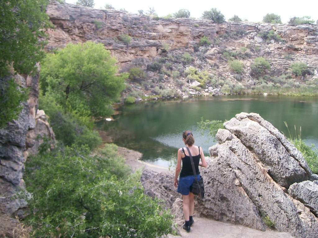
Dana had a hard time picking on a favorite photo, so instead she picked a favorite geologic place to go to. Can’t you imaging yourself going there for some peace and quiet? Isn’t it a fantastic place to visit?
Here’s a little of what she wrote: ……. we’ll do this. We’ll cut to the chase and play a favorite – a favorite place, one of my favorite places in the world. We’ll take a trek through the desert and come upon an oasis.
Down around Camp Verde in Arizona, you’ll come across a picture-perfect karst terrain. The old beds of lake-deposited limestone lay flat, dry and hot under the sun, carved into gullies and hills by wetter times. In some places, sinkholes pit the scenery. They’re lovely examples of the power of water and gravity together to sculpt the scenery.
Camp Verde got its name because a river runs through it, causing a line of green to conga through the hot, scrubby hills. It was enough of a shock that explorers named it the Verde River, because it was very nearly the only green thing they’d seen for absolute miles.
You will have to go to her blog to read more about this delightful place.
The old Sinagua canal
She ended with and I agree: Now that you’ve had a nice rest at the water’s edge, on with the parade!
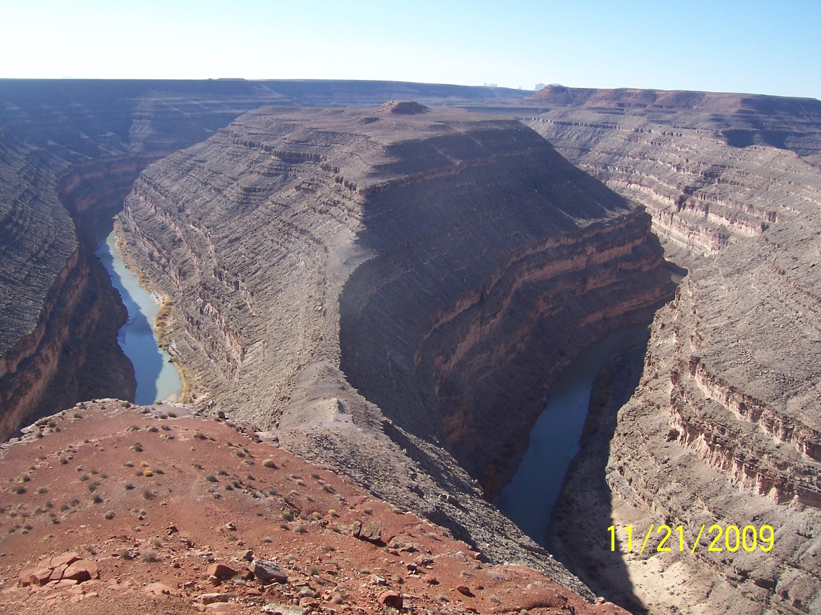
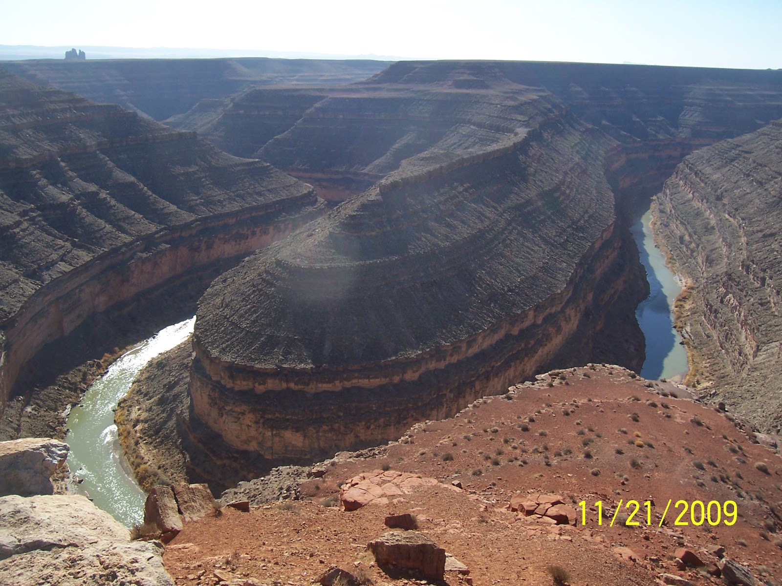
Well since I have done this for a previous AW, I will switch up the picture I used and this time give you a couple of glimpses into the Gooseneck of the San Juan River.
He writes: So here’s one of my favorite pictures – Haleakala crater. Technically, this isn’t the actual crater, it’s the eroded summit, widened by erosion. The smaller hills are cinder cones that erupted after most of the shield volcano was eroded away.
Here’s the float from Jessica at Magma Cum Laude with this beautiful picture. She writes: One of my favorite geologic photos is plenty colorful – and it’s also from my first field course, a month-long tour of the Colorado Plateau. The contrast between the sand and sky at Coral Pink Sand Dunes State Park in Utah is truly striking, and it was one of my favorite stops on the trip – because it’s also an excellent place for a game of frisbee!
From Evelyn we have a first time entry for the AW. Welcome aboard Evelyn!!! Here’s her float from Georneys
She writes: One of my favorite geology pictures (I have several- so difficult to chose!) is a picture of my favorite campsite ever. The picture below shows a makeshift campsite just off a road in northern Oman. The beautiful mountain in the background is Jebel Misht, one of several exotic limestones in the middle of the Samail Ophiolite. I was lucky enough to spend a few nights at this campsite in 2009 and 2010 as part of my PhD thesis fieldwork. One of my field sites, located near the small village of Al-Bana and close to the Misht campsite, has been named “Jebel Misht Travertine” by my research group.
Jebel Misht is a popular climbing destination. Making your way up the tall southeast cliff is not an easy task. When a French team of climbers accomplished the first successful ascent of Jebel Misht in 1979, the Sultan of Oman arranged to have the climbers picked up by helicopter from the top of the mountain and whisked off to the palace for a celebration. Jebel Misht means “Comb Mountain” in Arabic. Indeed, the mountain’s majestic cliff resembles a gigantic comb resting peacefully amidst the seafloor rocks of the ophiolite.
I am glad she came up with something and has joined the parade!!
From the float at Mountain Beltway Callan has these interesting things to say:
He writes.…. While it’s not my favorite, it’s definitely a favorite, more by virtue of the geology it shows than the aesthetic qualities of the image:
That is an outcrop of the French Thrust, one of many imbricate thrust faults exposed in Sun River Canyon, Montana, just west of Augusta. The light colored rock at right is limestone and dolostone of Mississippian age, and the dark rock at the lower left is shale of Cretaceous age (deposited in the Western Interior Seaway). Beyond that, to the very far left, you can see some lighter-colored, poorly-sorted material. That’s Pleistocene glacial till, and both the shale and the till are capped by a sloping layer of colluvium, tumbling down from higher elevations. The contact between the shale and the dolostone is a thrust fault. Half a mile downstream there is another. Half a mile upstream there is another. There are a lot of them exposed in Sun River Canyon, and the Canyon cuts across strike of all of them. Note the syncline in the Mississippian carbonates, and the differential weathering of the carbonate (tough, proud) as compared to the shale (weak, depressed). Here’s an annotated version of the photo: The Sun River Canyon is an unparalleled location in my experience for gorgeous scenery, great weather, a minimum of people, a healthy population of great gray owls, and exceptional exposures of an imbricate stack of thrust sheets. Check out this old post I put up at Pathological Geomorphology for more details about the area.
It’s always hard to pick a favorite geology picture, but this wintery Crater Lake panorama tops my list right now. Crater Lake is one of my favorite places, and it was exciting to visit in the winter! The perfect mirroring effect was particularly stunning. In person, the sky and water were the same color, making the caldera look like an arch in the sky.
Julia has a very intriguing float from Stages of Succession . You need to make sure you get a good look at what you are seeing. Please go to her blog to figure out if you are right or not.
Gareth’s float at Science 2.0 is very interesting to see because it has a volcanic bomb in it. This is one of the few bombs I care to see. In fact I wouldn’t ming going to Satorini to check it out for myself.
Despite my relatively short career as a geologist, it was a hard choice. There was a spectacular fault outcrop in Arkitsa, Greece; some impossible-looking resistant beds sticking straight out of the forest near Benés in the Catalan Pyrenees; and the classic ‘ripples on a vertical surface‘ to illustrate tectonic forces, also in the Catalan Pyrenees. However, I decided on this photo in the end, mainly because now I am a proper volcanologist I felt I should choose a volcano-related picture.
The photo is from Santorini, and shows a volcanic bomb. The layer it has impacted into is about 2m thick. While this is far from the largest bomb on the island, the way it is exposed here really does emphasise the power released when a volcano decides to blow.
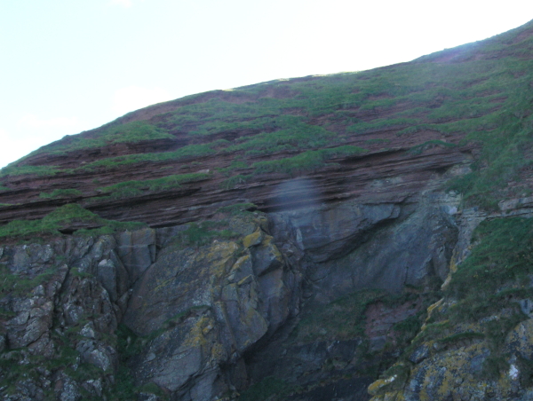
The Eagle Mts. (an Oligocene caldera) were the site of my originally-intended Master’s Thesis work, during the summer of 1978. The photo here was taken from the East Mill area, where we camped, for several weeks, while we mapped the southeastern portion of the mountains. In the near foreground is a portion of Wyche Ridge, composed of Cretaceous sedimentary rocks, forming part of the margin of the caldera.
Please go to his blog to read the rest of what he has to say about this area.
This what John has to say about his picture: Last summer I drove out to Bozeman, Wyoming for a GIS conference and took a rather circuitous route both outward from and back into Vermont. We decided to camp at Buffalo Bill State Park along the reservoir and then return to Cody after setting everything up. On our way back into Cody, just before the famous rodeo stadium, the setting sun illuminated this fantastic angular unconformity exposed in the Shoshone River. Based solely on the descriptions found in Torres and Gingerich (1983) I think the lower reddish unit is the Eocene Wildwood Formation overlain by the volcaniclastic Aycross Formation. I haven’t done any work at all, so this is solely based on reading geologic descriptions, hope I’m close.
View Angular Unconformity in a larger map And here is a closer view of the contact; again I ‘think’ my interpretation is correct but please advise if I’m off base here!
Ian at Hypo Theses has another fascinating picture of distant shores for his float.
John wrote:……It shows the foreshore at West Angle Bay, Pembrokeshire, Wales. The view looks westwards towards Milford Haven and shows the Lower Carboniferous Limestone contorted by a series of Variscan thrust related folds. One of the thrust planes is seen in the left of the image, over-steepened by the folding. To the centre of the image are a pair of whaleback periclinal anticlines. The beds then steepen again to vertical on the right via a tight syncline. But the beauty of a gigapan image is that one can dive in and view the detail like the slickenside lineations on the thrust plane or the writing on the buoy.
Long before I had a digital camera, I used a particular slide from a trip in the 1980s to introduce my students to the idea of the fascination of geology. It was taken next to one of the most famous photography spots in our national park system, but it is not a picture of the iconic feature. It’s the trail leading to it. Delicate Arch of the “Real” Jurassic Park lies just around the corner, and a crowd is often found there, especially at sunset. But I see fewer people stop and consider this scene….
I got into geology in part because of the wonderful journey of imagination that it is; a geologist is a world traveler, and a time traveler. The trail in this picture is formed on a natural break in the rock. Why is the break there?
In Jurassic time 180 and 140 million years ago, tidal flats and coastal sand dunes spread across this part of Utah. The surfaces of the dunes were pathways for all kinds of creatures, from insects to giant lumbering dinosaurs. The walked and crawled on these sands, and later the surfaces were preserved by subsequent layers of windblown sand. The surface later hardened a bit more than the others, and millions of years later, erosion exposed the old sands. A fracture developed along the surface, and the trail-builders of a few decades ago found it a great deal easier to just remove the overlying rock than to carve a new flat surface at great expense. And so it is that during our brief sojourn on the planet, we walk on the same surface, and perceive the significance of that fact. We use our minds to explore strange alien worlds, and yet these are the worlds that existed before ours and which became the raw materials for our own. Again, practically everyone walks up to Delicate Arch, but there is another arch just a few steps off the trail that provides a stunning view the distant La Sal Mountains, the laccolithic cores of 25 million year old volcanoes. This picture, taken just a few yards from the one above, contains the four elements of ancient human thought: water, earth, fire and sky (the water is in the sky and in the creek below). The essence of earth science…
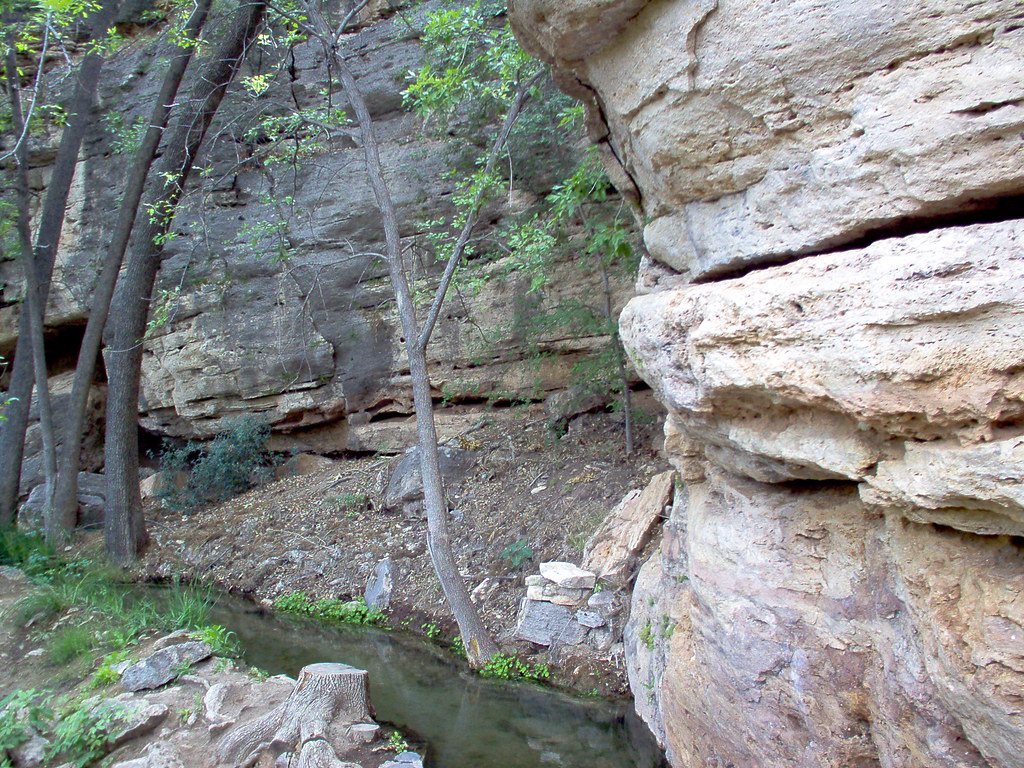
This one is from New Zealand. The Nile River Caves (as featured in WOGE #263) are on the north-west side of South Island, New Zealand, and as well as the expected beautiful limestone features, have some wonderful glow-worms and some rather interesting strata.
This one in particular is a mixture of mudstone and limestone. By the time this layer emerges at the coast at Punukaki, it’s more clearly layered and makes the Pancake Rocks.
Yes, I have amazing glacier and volcano shots. But this one is the one that says “Geology” to me the loudest.
The float Elli has submitted at Life in Plane Light has this amusing tale to tell…
For my PhD research, I ended up working in the Swiss Alps. Day one out was long, long, long (and it was magically also my birthday). By the time we reached the col that was going to actually become my field area it was rather late in the day and we were still 1000 m above the closest road. Bridget (my field assistant) and I were wearing every item of clothing that we had in our packs due to the cold (there was still snow on the ground & it was July). Before we could call it a day, we decided to collect four samples (we had a number of other rocks from earlier at other sites to the south of the col). Three popped out without an issue in reasonable sizes (enough for thin sections, tomography, and bulk chemistry), but the fourth was stubborn. It came off in a huge sheet:
the large slab (behind the hammer) that eventually became 04AD15; Tom Foster in blue, Hannes Hunziker in the middle, and Lukas Baumgartner in pink
while Bridge and I proceeded to shiver, these three male geologists tried to get 04AD15 down to a reasonable size. They used the sledge. They used a hammer with a chisel. They hopped up & down on the slab. They wedged another rock underneath the slab and tried everything again. Eventually, pieces started to fall of the edges. In the end, 04AD15 is still my largest sample. But its also my best sample of the bunch (including what I got a year later!), so all that work was worth it. But whenever I look at anything related to the sample, I have to imagine three senior geologists trying like crazy to break the slab
The March edition of the Accretionary Wedge geoblog carnival is at Ann’s Musings, and the theme is a deceptively simple summons: “Throw me your ‘favorite geologic picture’ mister.” This is nigh-on impossible and has led to some considerable introspection, not to mention scrabbling around to see what candidates I have with me on my laptop. But the scrabbling stopped as soon as I reminded myself of the image above. At first glance, perhaps it’s not strictly geological – but then again, yes it is. And, because of the very personal impact, it’s one of my favourite pictures – ever. It’s from a location in the remote south-western corner of Egypt, a Louvre of rock-art. This is just a small exhibit in a cave shelter covered in human expressions. The setting is geological, the canvas is geological, and the materials are geological, and all combine in the message of the connection between humans and geology. But of course it’s even more than that – we have no idea really who the artists were, exactly when they lived, what the function of this place was in their society, or why they expressed themselves so exuberantly. But the emotional resonance, sitting there gazing at this, has become deeply ingrained; there is an immediate, intensely human, connection with two unknown people who chose to record their hands reaching out to each other. It’s not even a picture of sand – but it is probably my favourite geological photo. And, in today’s world, perhaps it has an important message.
In a first moment I couldn’t decide what image to take, the classic outcrop or the marvellous landscape? – but there is an elder picture of 2007 I really like, at a first glimpse it’s geological context is not obvious, but this is also a reason that I like this particular picture.
The photo shows a species of club moss emerging from a pile of rubble. The club moss Huperzia selago is one of the two species of this genus present in the Alps; this species in particular can be found in high altitude and in glacier forelands, acting as pioneer species.
This specimen was emerging from gneiss and schist debris covering an active rock glacier; I like the contrast of the green plant to the cold grey of the rocks forming a sort of picture frame, the impression that the club moss overcomes every obstacle, even “breaks” the rocks apart to emerge from the underground.
For plants creeping debris and permafrost represent an ulterior challenge for colonization and growth in an already nasty environment, with long snow cover, low temperatures and deadly UV-radiation. I think the picture depicts well the struggle of existence in a harsh environment – but as the the rocks act as obstacle they at the same time also provide shelter, moisture and nutrients.
For the geologist also the recognition of even the smallest clue can be helpful, I find it fascinating how many different methods can be adopted to understand the development of a geomorphologic feature or a landscape – in combination with classic geological methods for example the vegetation cover or diversity can give indications of the recent activity of rock glaciers, or help to reconstruct the temporal development when other indicators are absent.
And finally the image remembers me as a sort of metaphor what the German geoscientist Gerd Lüttig argued in 1971:
“Earth history can be described as a permanent interaction between the geosphere (lithos) and life processes (bios). To investigate these processes is the mission of Lithobiontics, a new research discipline between Geology and Biology.“
In a post about Multnomah Falls and Columnar Jointing, I posted this picture taken of Sam at Devil’s Tower a few years ago. It remains one of my favorite pictures of geology (and Sam) as it provides such a great image to show several geologic principles at ones. Aside from the geologic signficance of the tower itself, the promionant geologic feature is the massive hexagonal piece that 7-year old Sam (for scale) is leaning against. Behind it, you can see the joints extending up the tower with clear hexagonal blocking roofs, allowing one to recognize the block as having weathered and fallen off the tower.
The picture also has trees and shrubs growing in the fractures below the main part of the tower. These fractures are not the columnar jointing of above, and so demonstrate a different condition of cooling for the base of the tower. The fractures below also have trees and shrubs growing amids the fractures illustrating yet another form of mechanical weathering.
This was taken from the appropriately named “Anticline Overlook” of the Canyon Rims Recreation Area in eastern Utah. The anticline is obvious, you can see the upward curve of the rock units. I love the part where the river cuts through the anticline making a natural road cut.
The river cuts through the Permian age Cutler formation, the left overs from the formation of the Ancestral Rockies. The upward arching of these rocks is from the squishing (a very technical term) of a buried salt layer. Far below the Cutler lies the Pennsylvanian Paradox formation, a mile thick layer of salt that has a tendency to move about creating some fun landscapes in the desert southwest. The buildings and ponds you see in the picture are a potash mine. Water is pumped underground into the Paradox layer, dissolves the salts and the brine is pumped back to the surface into the blue evaporation ponds in the background. The water evaporates away leaving the salts for transport.
The fun part of this area are the roads. They are barely visible in the picture but they travel hundreds of miles through the red rock desert . A mountain biking heaven!
Cain at Point Source has added this last entry to the parade of picture floats.
(I’m having trouble with this link so here it is http://cbdawson.com/blog/2011/03/aw32-arachnoids-on-venus-2/ ) In the midst of reorganizing, I recently unearthed some deeply buried personal geologic records from past research projects. One discovery was an image that previously adorned my wall: a MagellanVenus.radar image of arachnoids on
Magellan radar image of arachnoids on Venus. (Image courtesy of NASA/JPL)
I think this image is a perfect fit for Accretionary Wedge#32 “favorite geologic picture.” It’s not the most colorful or dramatic image, but it holds an important place in my professional experience in the geosciences. Arachnoids are geological features on Venus. They are characterized by a combination of radar-bright, concentric rings (like a bull’s eye) and radiating lineations (line-like features) and were named “arachnoids” because of their spider and web-like appearance. Although these features had been identified on earlier Soviet Venera mission data, the NASA Magellan mission provided sufficiently high resolution radar imagery and elevation data to investigate them more closely. These features were one of my first forays into geology research as an undergraduate student. What were they? Did all features catalogued as arachnoids based on the radar images have similar topographic features? What caused them? Where they all the same age? Where were they located? Was there a terrestrial geology analog? I had many questions, a patient research advisor, and a short summer. The personal outcome was clear, though: I was hooked. Geology was fascinating, no matter where in the solar system. There were so many questions, and we didn’t have all the answers! This was a far cry from the textbook science of packaged information and rote facts to memorize. The science was alive, the questions infinite, and the data plentiful. Whenever I see these data images, they represent all of this in one snapshot: the excitement and mystery of geology.
He has more but you just have to go to his blog to read the rest of it.
And finally here’s the Captains float –
The Red River at sunrise, seen from a balloon about 1000 feet up in the air.
The Red River
The beads are thrown and are now on the wire connecting to the internet web. I hope you had a good time.
Now all good things must come to an end. The parade is over and it is time to go home. Thank you one and all for submitting something for this Accretionary Wedge – 32.
If you had something and didn’t get it in or if I missed it please leave a comment and I will add it later.
Post script:
Here’s a little bit about Mardi Gras for those who don’t celebrate it like we do in Louisiana.
For those of you who don’t know its officially Carnival time or Mardi Gras season (Twelfth night to Fat Tuesday i.e. Jan 6 to March 8 this year). Twelfth night is also know as the feast of the Epiphany and is celebrated by Christians as the day the three wise men came to visit the baby Jesus and is 12 days after Christmas. Fat Tuesday is the day before Ash Wednesday. Ash Wednesday is the first day of lent, a time where you are suppose to make sacrifices and give up things, in preparation of Easter which is 40 days later. Because people may give up drinking, certain foods etc for the forty days during lent they like to have a big blow out where they consume the food that they will be giving up. They usually do this the day before and thus the reason it is called Fat Tuesday or as the French call it Mardi Gras.
To celebrate together different groups of people with like interests get together and form Krewes. Most Krewes have a theme by which they go by. For example, in my area of LA there is a Krewe of doctors call Aesculapius and another one for Lawyers called Justinian and one of cat and dog lovers called Barcus and Meow. I am a member of the Krewe: Les Femmes Mystique. If you haven’t guessed it – its a group of women who are concerned about the community. Although we enjoy our parties we also like to give something back to the community. Every month we have a project to work on. This keeps the Krewe together during the year when the parties are not going on. Every month there is a different project, such as working at the food bank, help run the Susan G Coleman race for cancer, the march of dimes walk, gathering school supplies for children, getting and wrapping toys for the Toy’s for Tots program, etc. It varies from year to year what all we do.
But the thing that most people know the Krewes by are by their parades. My Krewe is not big enough to have a parade of their own so we augment other parades in the area by joining in on other floats in the parades. When you are on a float, you provide all of your own throws – the things you toss to people. People love to come and watch these parades because of the gaudy decorations and the stuff that gets tossed to them. Beads are the most common thing, but there are also other things tossed to like stuff animals, wrapped candies/food, plastic cups and fake coins called doubloons (which can become a collectors item). It’s whatever you want to buy and spend, but you are restricted to things that can’t hurt if tossed, also it can’t be offensive to the public in general.
If you ever go to a Mardi Gras parade there are certain things you should know. Namely they can’t throw anything if the float is not moving, so don’t try to stop a float to get something from it. Also if it lands on the ground put your foot on it and then after the float has gone by then reach down and pick it up. If you try to reach down and grab it expect someone to stomp on your hand. Also when the float goes by everyone says ‘Throw me something Mister’. The reason they do that is because the people on the floats are usually in costumes, with their faces covered. They cover their faces so they can remain anonymous.
Elaborate costumes are common with the Carnival. Most Krewes have a King, and a Queen and a Captain the rest of the float leaders are called Dukes and Duchess. Because they are royalty they like to dress up to the part, thus the elaborate costumes. These people hold their offices for one year, and then switch off at coronation Bals. There is also another bal that is thrown during the Carnival time where the other royalties come together to enjoy the hospitably of the different Krewes. The Captain of the Krewe organizes the bals and parade and is the person who is in contact with the other Krewes. The King and Queen are the official representatives of the Krewe for that year and are expected to attend most events. The King and Queen are very rarely married to each other. The spouse or significant other of the Royalty person is officially named their consort.
Mardi Gras is all about having fun and celebrating life. It is also about giving back to the community in which they live as a ways for friends and neighbors to get together so they can get to know each other better. For more about Mardi Gras here Wikipedia Mardi Gras.
Post Script:
I do want to thank everyone. I did have some technical difficulties with this but eventually figured things out. I do want to thank Callan for helpful suggestions, while I tried to get it done. I must admit I agreed to be a host more for my own benefit than yours. I’ve very inept with computers and doing things like this teaches me so much. I also do it so I can see all the amazing things that have developed in the geology field since I was last active in it. I enjoyed putting this blog together and it wouldn’t have been possible if it wasn’t for all the contributions I got. Again THANK YOU.
Here are the topics and hosts for the next 4 editions of the Accretionary Wedge:
#33 – April – John Van Hoesen of Geologic Musings in the Taconic Mountains hosts. He asks, “How much or what kind of ‘geology’ have you incorporated into you home / living space?”
#34 – May – Dana Hunter ofEn Tequila Es Verdad hosts. The theme is “Weird Geology.”
#35 – June – Evelyn Mervine of Georneyshosts. The theme is “my favorite geology word.”
#36 – July – “Ontherocks” of Geosciblog-science hosts. The question is: “What past mineral/fossil locality have you regretted not collecting more specimens from?”
Thanks to these geobloggers for volunteering to host. If anyone else wants to claim a future Wedge, let us know when and who and what via the comments.